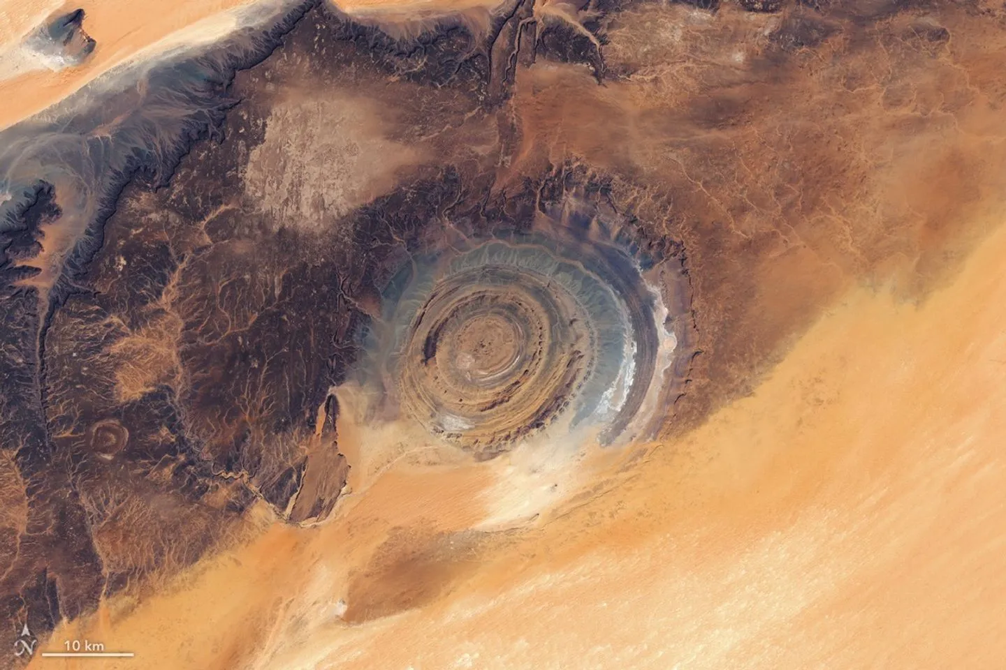
On the Adrar Plateau in northern Mauritania lies a landscape that is nearly impossible to appreciate from ground level. Rocky ridges, barely noticeable up close, form a near-perfect ring 40 kilometers (25 miles) across — a shape that only reveals itself from above.
A recent NASA Earth Observatory image captures this formation in detail. It's a mosaic built from data collected by the OLI instrument aboard Landsat 8 and Landsat 9 on March 5 and 6, 2026. The composition was put together by Lauren Dauphin.
From the Richat "buttonhole" to the "Eye of the Sahara"
French geographers first described the feature in the 1930s, calling it the Richat "buttonhole" for the way its concentric ridges resembled a fastening loop.
The structure gained wider recognition in 1965, when astronauts Ed White and James McDivitt photographed it during the historic Gemini IV mission. That orbital photograph is where the nickname "Eye of the Sahara" comes from — from space, the formation does look like a giant bull's-eye set into the desert.
A dome, not a crater
The circular shape initially led researchers to suspect an impact crater. Large meteorites can leave similarly round marks on Earth's surface.
Later studies told a different story. The Richat Structure is a deeply eroded geologic dome. An underground intrusion of igneous material once pushed the overlying rock layers upward.
Erosion did the rest. Different rock types wore away at different rates, carving the uplifted dome into the ring-shaped ridges known as cuestas. The orange and gray tones visible in the image reflect the contrast between sedimentary and igneous rocks that make up the structure and the surrounding terrain.
A desert shaped by wind — and by people
The region around the Richat Structure has been shaped largely by natural forces. Wind sculpted seas of colorful sand dunes and stripped plateaus down to a dark "desert pavement" of tightly packed stones, while ancient flowing water carved valleys and networks of dried river channels still visible today.
But the same landscape also holds traces of human presence. Paleolithic stone tools, Neolithic cave paintings, and the ruins of medieval towns once used by caravans crossing the Sahara have all been found here. The desert around the "Eye of the Sahara" turns out to be as much an archive of human history as it is of geology.