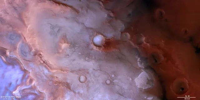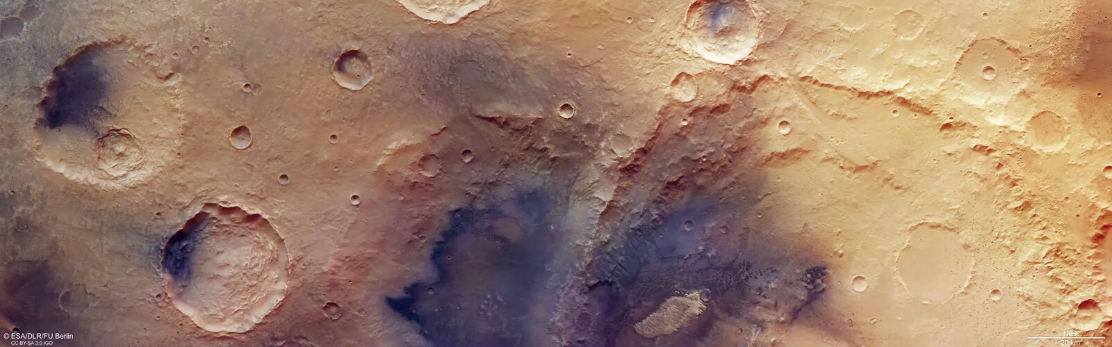
ESA's Mars Express has returned a new image of a section of Arabia Terra — one of the oldest plains in Mars's ancient highlands. The terrain is estimated to be between 3.7 and 4.1 billion years old, and over that time it has accumulated dozens of craters in varying states of preservation. The image, captured by the High Resolution Stereo Camera (HRSC), reveals several chapters of Martian history at once — from impact craters to traces of wind and, possibly, water.
Trouvelot Crater and its crumbling neighbour
The largest feature in the frame is Trouvelot Crater, roughly 130 km across. Its rim began crumbling long ago, and its interior walls have collapsed into uneven "terraced" ledges under their own weight over billions of years. Smaller, later craters overlap inside it, showing that impacts continued to strike the region even after Trouvelot itself formed.
To the left of Trouvelot sits another, even older basin, its wall almost entirely worn away. Trouvelot cuts through part of this crater, indicating that its neighbour predates it.
Dark volcanic rock and barchan dunes
The floor of the older crater is almost entirely covered in dark rock rich in magnesium and iron — minerals such as pyroxene and olivine, typical of volcanic (mafic) material. This rock likely reached the surface during the impacts that carved out the craters, and was later reshaped by wind and gravity as material slid down the crater walls.
Similar dark deposits appear on the floors or walls of other large craters across Arabia Terra, beyond the edges of this frame, suggesting these processes are widespread in the region.
Inside Trouvelot Crater, wind has sculpted the dark material into crescent-shaped dunes known as barchans, which form where wind blows predominantly in one direction. Mars Express has spotted similar dune fields before, in Mars's north polar region and near the volcanic province of Tharsis.
A light-toned mound and signs of water
Standing out against the dark rock inside Trouvelot is a light-toned mound about 20 km long, marked by ridges and grooves. Similar light formations have been observed elsewhere on Mars, including in nearby Becquerel crater, imaged by Mars Express in 2013 and 2014.
Such mounds typically contain minerals that formed in contact with, or in the presence of, water. Exactly how the mounds themselves formed is still debated: one idea is that they once sat at the bottom of a lake or sea; another is that light-toned layers built up gradually as groundwater rose and mixed with wind-blown sediments on the crater floor.
Two decades of HRSC observations
The image was captured by the High Resolution Stereo Camera, one of eight instruments aboard Mars Express. The orbiter has been exploring Mars since 2003, and over more than two decades has mapped the planet's surface at high resolution, in colour, and in three dimensions. The camera was developed and is operated by the German Aerospace Center (DLR); data processing takes place at the DLR Institute of Space Research in Berlin, while the imagery is produced by a working group at the Freie Universität Berlin.
Each new frame of Arabia Terra adds another piece to the picture of what Mars looked like billions of years ago — when water may still have flowed across its surface.